
Florida Everglades
(Excerpt from USGS Circular 1182)
(A pdf of the of the entire circular is
available. Information about ordering
Circular 1182 can be found at the end of this page)Subsidence threatens
agriculture and complicates ecosystem restoration
Christopher
McVoy B. Glaz Winifred
Park
S.E. Ingebritsen
U.S.
Geological Survey, Menlo Park, California
South Florida Water Management District, West Palm Beach,
Florida
U.S.
Department of Agriculture, Agricultural Research Service, Canal
Point, Florida
South Florida Water Management District, West Palm Beach,
Florida
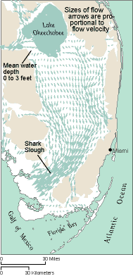
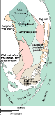
The Everglades ecosystem includes Lake Okeechobee and its tributary areas, as well as the roughly 40- to 50-mile-wide, 130-mile-long wetland mosaic that once extended continuously from Lake Okeechobee to the southern tip of the Florida peninsula at Florida Bay.
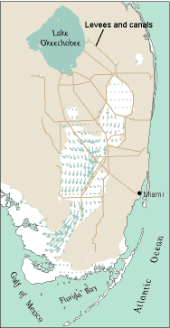
Since 1900 much of the Everglades has been drained for agriculture and urban development, so that today only 50 percent of the original wetlands remain. Water levels and patterns of water flow are largely controlled by an extensive system of levees and canals. The control system was constructed to achieve multiple objectives of flood control, land drainage, and water supply. More recently, water-management policies have also begun to address issues related to ecosystem restoration. Extensive land subsidence that has been caused by drainage and oxidation of peat soils will greatly complicate ecosystem restoration and also threatens the future of agriculture in the Everglades.
- Majorie Stoneman Douglas,
1947
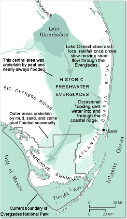
"The outline of this
Florida end-of-land, within the Gulf of Mexico, the shallows of the
Bay of Florida and the Gulf Stream, is like a long pointed spoon.
That is the visible shape of the rock that holds up out of the
surrounding sea water the long channel of the Everglades and their
borders. The rock holds all the fresh water and the grass and all
those other shapes and forms of air-loving life only a little way
out of the salt water, as a full spoon lowered into a full cup holds
two liquids separate, within that thread of rim."
The Everglades ecosystem has, in fact, been badly degraded, despite the establishment of Everglades National Park in the southern Everglades in 1947. Prominent symptoms of the ecosystem decline include an 80 percent reduction in wading bird populations since the 1930s (Ogden, 1994), the near-extinction of the Florida panther (Smith and Bass, 1994), invasions of exotic species (Bodle and others, 1994), and declining water quality in Florida Bay, which likely is due, at least in part, to decreased freshwater inflow (McIvor and others, 1994).
Historic Flows Were Severed
|
Early agriculturalists began the drying process
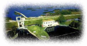
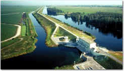
Hoover dike (center) was built with digging spoils obtained
from a navigable channel (foreground). Lake Okeechobee is at the top
of photo. (Click on image for larger
version.)
The first successful farming ventures in the Everglades began in about 1913, not on the sawgrass plain itself but on the slightly elevated natural levee south of Lake Okeechobee (Snyder and Davidson, 1994). Early efforts to clear, farm, and colonize the sawgrass area had little success, being plagued by flooding, winter freezes, and trace-nutrient deficiencies. (The soil beneath the sawgrass was later shown to be too low in copper to support most crops and livestock.)
In the 1920s the State of Florida established an Everglades Experiment Station in Belle Glade, and the U.S. Department of Agriculture established a Sugarcane Field Station in Canal Point. The combined efforts of these units gradually solved the plant- and livestock-pathology problems experienced by early farmers. However, the land was still subject to frequent, sometimes catastrophic inundation. The great hurricane of 1928 caused at least 2,000 fatalities and flooded the Everglades Experiment Station for several months.
|
Further water-management efforts accelerated development
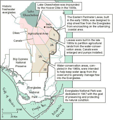
A comprehensive Federal-State water-management effort in the 1950s and 1960s was prompted by drought and widespread fires in 1944 to 1945 and renewed flooding in 1947 to 1948. The primary motivation was flood control and water supply for the growing urban areas along the Atlantic coast. The drying of the Everglades had clearly contributed to rapid saltwater intrusion in these urbanizing areas during the drought.

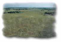
Water conservation area 2A is mostly covered with sawgrass.
(Click on image for larger
version.)
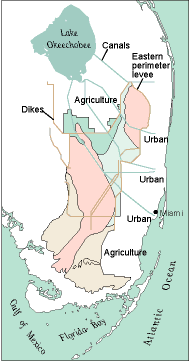
A regional flood-control district, the predecessor of today's South Florida Water Management District, was created by the State of Florida in 1949 to manage a coordinated water system. The urbanizing areas that extended west of the natural bedrock ridge were protected from flooding by a high levee known as the "eastern perimeter levee." Although it was originally built to protect and promote development of urbanizing areas along the southeastern coast, this levee has, ironically, become the only effective barrier to more extensive urban development of the Everglades (Light and Dineen, 1994).
An area of thick peat soil south of Lake Okeechobee was designated the "Everglades agricultural area." Farther south, other areas of peat soils less suitable for agriculture were designated as "water-conservation areas." These areas are maintained in an undeveloped state, but a system of dikes and canals allows water levels to be manipulated to achieve management objectives that include flood control, water supply, and wildlife habitat.
Water management has brought significant changes to natural
overland flow patterns.
During dry periods, the level of Lake Okeechobee drops as water is released to provide water to the agricultural area, to canals that maintain ground-water levels in urban areas along the Atlantic coast, and to Everglades National Park. At other times, drainage water pumped from the agricultural area is released into the water-conservation areas, providing needed water but also undesirable amounts of the nutrient phosphorus. In recent years, "best management practices" have helped reduce phosphorus loads from the agricultural area. The managed part of the remaining Everglades-approximately the northern two-thirds-now consists of a series of linked, impounded systems that are managed individually.
With the addition of trace nutrients, the peat soil or "muck" beneath the sawgrass proved extremely productive. But the farmers also saw
"... the cushiony layer of dark muck shrink and oxidize under the burning sun as if it was consumed in thin, airy flames. As the canals and ditches were extended by the local drainage boards, and the peaty muck was dried out and cultivated, it shrank ... It is still shrinking. Every canal and ditch that drained it made a long deepening valley in the surrounding area. On the east and south the subsidence was so great that half that land [drains towards] the lowered lake." -Marjorie Stoneman Douglas, 1947
In today's Everglades agricultural area,
evidence of substantial land subsidence can readily be discerned from the
relative elevations of the land surface, the drainage-canal system, and
the lake, and from the elevation of older buildings that were built on
piles extending to bedrock. Precise measurements are relatively rare,
except at particular points or along a few infrequently revisited
transects. However, the long-term average rate of subsidence is generally
considered to have been between 1 and 1.2 inches per year (Stephens and
Johnson, 1951; Shih and others, 1979; Stephens and others, 1984).
In uncultivated areas of the Everglades, subsidence is less obvious but probably widespread. Subsidence is not caused by cultivation, but occurs wherever drainage desaturates peat soil. Early engineering efforts focused on drainage alone, and, as a result, much of the area became excessively drained during drought years. The "river of grass" often became a string of drying pools, and great fires swept the Everglades. The drying triggered subsidence, which was then exacerbated by widespread fires. The persistent peat fires sometimes continued smoldering for months before being extinguished by the next rainy season.
Conventional surveying has always
been extremely difficult in the Everglades. Stable bedrock bench marks are
nonexistent or very distant, the surficial material is soft and yielding,
and access is difficult. Current best estimates suggest that there have
been 3 to 9 feet of subsidence in the current Everglades agricultural area
and that an equally large uncultivated area has experienced up to 3 feet
of subsidence. Such elevation changes are tremendously significant to a
near-sea-level wetlands system in which flow is driven by less than 20
feet of total relief.
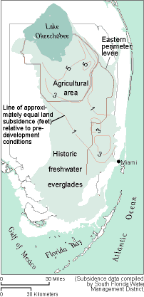
Subsidence is greater in areas that were intentionally
drained for urban and agricultural
uses.
The current management infrastructure and policies have abated land subsidence in undrained areas of the historic Everglades to some extent, although comparison of recent soil-depth measurements by the U.S. Environmental Protection Agency (Scheidt, US EPA, written communication 1997) with 1940s estimates of peat thickness (Davis, 1946; Jones and others, 1948) suggest that there has been widespread subsidence in the water-conservation areas over the past 50 years. The northern parts of individual water-conservation areas may still experience some minor subsidence. The southern or downstream parts of the impoundments are generally wetter and may be accumulating peat (Craft and Richardson, 1993a, 1993b), very gradually increasing in elevation. In the drained agricultural and urban areas, subsidence is an ongoing process, except where the peat has already disappeared entirely.

This building at the Everglades Experiment Station was
originally constructed at the land surface; latticework and stairs
were added after substantial land
subsidence.
A sugar mill outside Belle Glade is
surrounded by sugar cane fields.
Note the dark peat soils in the lower
photograph.
Subsidence Clouds the Future of Agriculture
The Everglades agricultural area is now mainly devoted to sugarcane, with considerably smaller areas used for vegetables, sodgrass, and rice. The value of all agricultural crops is currently about $750 million (Snyder and Davidson, 1994).
The eventual demise of agriculture in the
Everglades has been predicted for some time (Douglas, 1947; Stephens
and Johnson, 1951). The agriculture
depends upon a relatively thin, continually shrinking layer of peat soil
that directly overlies limestone bedrock. Agronomists have known for many
decades that peat-rich soils (histosols), which form in undrained or
poorly drained areas, will subside when drained and cultivated. The causes
include mechanical compaction, burning, shrinkage due to dehydration, and
most importantly, oxidation of organic matter. Oxidation is a microbially
mediated process that converts organic carbon in the soil to (mainly)
carbon dioxide gas and water.
Through photosynthesis, vegetation converts carbon dioxide and water into carbohydrates. Under natural conditions, aerobic microorganisms converted dead plant material (mostly sawgrass root) to peat during brief periods of moderate drainage. Vegetative debris was deposited faster than it could fully decompose, causing a gradual increase in peat thickness. In what is now the Everglades agricultural area, a delicate balance of 9 to 12 months flood and 0 to 3 months slight (0 to 12 inches) drainage for about 5,000 years, with sawgrass the dominant species, led to a peat accretion rate of about 0.03 inches per year. Drainage disrupted this balance so that, instead of accretion, there has been subsidence at a rate of about 1 inch per year.
Peat soils may virtually disappear
Rates of subsidence in the Everglades are slower than those in the Sacramento-San Joaquin Delta of California, the other major area of peat-oxidation subsidence in the United States; in the Delta, average subsidence rates have been up to 3 inches per year. However, the preagricultural peat thickness was much greater in the Delta (up to 60 feet) than in the Everglades, where initial thicknesses were less than 12 feet. The subsidence rates observed in the Everglades are similar to those observed in the deep peat soils of the English fens during the past 100 years (Lucas, 1982; Stephens and others, 1984).
(Stephens and Johnson, 1951)
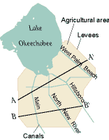
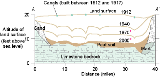
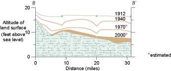
Two cross sections through the agricultural area show the
drop in land-surface elevation.
In the Everglades agricultural area, the
initial peat thickness tapered southward from approximately 12 feet near
Lake Okeechobee to about 5 feet near the southern boundary. In 1951,
Stephens and Johnson extrapolated contemporary subsidence trends to
predict that by the year 2000 the peat soil would be less than 1 foot
thick in about half of the area. They further inferred that much of the
area will by then have gone out of agricultural production, assuming that
cultivation would not be possible with less than 1 foot of soil over
limestone bedrock.
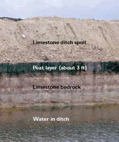
A ditch excavation east of Belle Glade shows peat soil
overlying limestone
bedrock.
Although the extrapolation of peat thickness done by Stephens and Johnson (1951) appears consistent with measurements made in 1969 (Johnson, 1974), 1978 (Shih and others, 1979), and 1988 (Smith, 1990), little land has yet been retired from sugarcane. One reason is that farmers have managed to successfully produce cane from only 6 inches of peat, by first piling it in windrows to allow successful germination. It also appears possible that the rate of subsidence has slowed somewhat (Shih and others, 1997), due to the combined effects of an increasing nonorganic (mineral) content in the remaining soil, a thinner unsaturated zone dictated by the decreasing soil depth and, perhaps, an increasing abundance of more recalcitrant forms of organic carbon.
The soil-depth predictions of Stephens and Johnson (1951) may prove to have been somewhat pessimistic, but it is clear that agriculture as currently practiced in the Everglades has a finite life expectancy, likely on the order of decades. Extending that life expectancy would require development of an agriculture based on water-tolerant crops that accumulate rather than lose peat (Porter and others, 1991; Glaz, 1995).
Subsidence Complicates Ecosystem Restoration
In a
wetland area where natural hydraulic gradients were on the order of inches
per mile, and one half-foot land-surface altitude differences are
ecologically significant, the fact of several feet of land subsidence
substantially complicates ecosystem-restoration efforts.
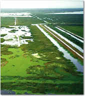
Canals and a levee separate constructed wetland from
the agricultural area to the
right.
Subsidence makes true restoration of the Everglades agricultural area itself technically impossible, even in the event that it were politically and economically feasible. Land there that once had a mean elevation less than 20 feet above sea level has been reduced in elevation by an average of about 5 feet. Differential subsidence has significantly altered the slope of the land, precluding restoration of the natural, shallow sheet-flow patterns. If artificial water management and conveyance were now to cease, nature would likely reclaim the land as a lake, rather than the predevelopment sawgrass plains. With removal of the "sponge" of peat and native vegetation, the agricultural area has also lost most of its ability to naturally filter, dampen, and retard storm flows. Other strong impediments to restoration of the Everglades agricultural area include loss of the native seed bank, accumulations of agricultural chemicals in the soil, and the potential for invasion by aggressive exotic species.
Subsidence will also complicate efforts to manage the water-conservation areas to the east and south in a more natural condition. For example, the wetlands in these areas are speckled with tree islands, which are an important ecosystem component. Though definitive data are lacking, these tree islands likely have subsided, possibly more than the surrounding area. Thus, restoration of the water-conservation areas will require careful management of water levels in a depth range sufficient to promote appropriate wetland species without further damaging tree islands.
Careful Water Management is a Key to the Future
Because
of peat loss, agriculture as currently practiced in the Everglades will
gradually diminish over the next decades. R.V. Allison, the first head of
the Everglades Research Station, likened the peat soil to "the cake which
we cannot eat and keep at the same time." His confident prediction that
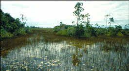
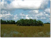
A tree island in the
Everglades
"As the use of Everglades lands for agricultural purposes approaches the sunset of ... production, there is little doubt that transition into a wildlife area of world fame will follow, perhaps in an easy and natural manner."
-Allison, 1956
now seems overly optimistic. This is still a possible scenario but, as we have noted, the result would be very different from the natural system, due to subsidence. There are also alternative possibilities, including urban development or invention of a sustainable agriculture.
A sustainable agriculture in the Everglades would require at least zero subsidence and, optimally, some peat accretion. Glaz (1995) discussed a program of genetic, agronomic, and hydrologic research aimed at gradually (over a period of 20 to 40 years) making a currently used sugarcane-rice rotation sustainable. Achievement of this goal may prove difficult. However, documented water tolerance of sugarcane (Gascho and Shih, 1979; Kang and others, 1986; Deren and others, 1991), a recently discovered explanation for this water tolerance (Ray and others, 1996), and rapid gains in molecular genetics combine to suggest that substantial reductions in subsidence might be attainable.
Even in the complete absence of agriculture in the Everglades, the existing pattern of urban development and land subsidence would prevent restoration of the natural flow system. Engineered water management and conveyance will be required indefinitely. Land subsidence over a large area south of Lake Okeechobee has created a significant trough within the natural north-south flow system, thereby preventing restoration of natural sheet-flow and vegetation patterns.
The Everglades are currently the
subject of a major Federal-State ecosystem restoration effort.
"Restoration" is perhaps a misnomer, as the focus of this effort is on
more natural management of the remaining 50 percent of the Everglades
wetlands, not on regaining the 50 percent that has been converted to urban
and agricultural use. Even improving the natural functioning of the
remaining wetlands will be a complex problem, due to the lost spatial
extent, the hydrologic separation from Lake Okeechobee, and land
subsidence. The Everglades will likely continue to be an intensively
managed system. However, much as the major engineering effort in the 1950s
and 1960s halted the destructive fires and saltwater intrusion of
preceding decades, the current restoration effort has the potential to
halt and reverse more recent environmental degradation. A major challenge
will be to deliver water from Lake Okeechobee through the extensive
subsided areas so that it arrives in the undeveloped southern Everglades
at similar times, in similar quantities, and with similar quality, as it
did prior to drainage and subsidence.
References
Allison, R.V., 1956, The influence of drainage and cultivation on subsidence of organic soils under conditions of Everglades reclamation: Soil and Crop Science Society of Florida Proceedings, v. 16, p. 2131.
Bodle, M.J., Ferriter, A.P., and Thayer, D.D., 1994, The biology, distribution, and ecological consequences of Melaleuca quinquenervia in the Everglades, in Davis, S.M., and Ogden, J.C., The EvergladesThe ecosystem and its restoration: Delray Beach, Fla.,St. Lucie Press, p. 341355.
Craft, C.B., and Richardson, C.J., 1993a, Peat accretion and N, P, and organic C accumulation in nutrient-enriched and unenriched Everglades peatlands: Ecological Applications, v. 3, p. 446458.
Craft, C.B., and Richardson, C.J., 1993b, Peat accretion and phosphorus accumulation along a eutrophication gradient in the northern Everglades: Biogeochemistry, v. 22, p. 133156.
Davis, J.R., Jr., 1946, The peat deposits of Florida: Florida Geological Survey Bulletin 30, 247 p.
Davis, S.M., and Ogden, J.C., eds., 1994, The EvergladesThe ecosystem and its restoration: Delray Beach, Fla., St. Lucie Press, 826 p.
Deren, C.W., Snyder, G.H., Miller, J.D., and Porter, P.S., 1991, Screening for heritability of flood-tolerance in the Florida (CP) sugarcane breeding population: Euphytica, v. 56, p. 155160.
Douglas, M.S., 1947, The Everglades River of grass: St. Simons Island,Fla., Mockingbird Press, 308 p.
Gascho, G.J., and Shih, S.F., 1979, Varietal response of sugarcane to water table depth, part 1. Lysimeter performance and plant response: Soil and Crop Society of Florida Proceedings, v. 38, p. 2327.
Glaz, Barry, 1995, Research seeking agricultural and ecological benefits in the Everglades: Journal of Soil and Water Conservation, v. 50, p. 609612.
Johnson, Lamar, 1974, Beyond the fourth generation: Gainesville, Fla., The University Presses of Florida, 230 p.
Jones, L.A., Allison, R.V., and others, 1948, Soils, geology, and water control in the Everglades region: University of Florida Agricultural Experiment Station Bulletin 442, 168 p., 4 maps.
Kang, M.S., Snyder, G.H., and Miller, J.D., 1986, Evaluation of Saccharum and related germplasm for tolerance to high water table on organic soil: Journal of the American Society of Sugar Cane Technologists, v. 6, p. 5963.
Light, S.S., and Dineen, J.W., 1994, Water control in the Everglades: A historical perspective, in Davis, S.M., and Ogden, J.C., The EvergladesThe ecosystem and its restoration: Delray Beach, Fla., St. Lucie Press, p. 4784.
Lucas, R.E., 1982, Organic soils (Histosols)Formation, distribution, physical and chemical properties and management for crop production: Michigan State University Farm Science Research Report 435, 77 p.
Matson, G.C., and Sanford, Samuel, 1913, Geology and ground water of Florida: U.S. Geological Survey Water-Supply Paper 319, 445 p.
McIvor, C.C., Ley, J.A., and Bjork, R.D., 1994, Changes in freshwater inflow from the Everglades to Florida Bay including effects on biota and biotic processes: A review, in Davis, S.M., and Ogden, J.C., The EvergladesThe ecosystem and its estoration: Delray Beach, Fla., St. Lucie Press, p. 117146.
Ogden, J.C., 1994, A comparison of wading bird nesting colony dynamics (19311946 and 19741989) as an indication of ecosystem conditions in the southern Everglades, in Davis, S.M., and Ogden, J.C., The EvergladesThe ecosystem and its restoration: Delray Beach, Fla.,St. Lucie Press, p. 533570.
Porter, G.S., Snyder, G.H., and Deren, C.W., 1991, Flood-tolerant crops for low input sustainable agriculture in the Everglades agricultural area: Journal of Sustainable Agriculture, v. 2, p. 77101.
Ray, J.D., Miller, J.D., and Sinclair, T.R., 1996, Survey of arenchyma in sugarcane roots (abs.): Fifth Symposium of the International Society of Root Research, July 1418, 1996, Clemson, S. C., p. 118.
Shih, S.F., Glaz, Barry, and Barnes, R.E., Jr., 1997, Subsidence lines revisited in the Everglades agricultural area, 1997: University of Florida Agricultural Experiment Station Bulletin 902, 38 p.
Shih, S.F., Stewart, E.H., Allen, L.H., Jr., and Hilliard, J.E., 1979, Variability of depth to bedrock in Everglades organic soil: Soil and Crop Society of Florida Proceedings, v. 38, p. 6671.
Smith, G., 1990, The Everglades agricultural area revisited: Citrus and Vegetable Magazine, v. 53, no. 9, p. 40-42.
Smith, T.S., and Bass, O.L., Jr., 1994, Landscape, white-tailed deer, and the distribution of Florida panthers
This page is: http://sofia.usgs.gov/publications/circular/1182/index.html
Comments and suggestions? Contact: Heather Henkel - Webmaster
Last updated: 11 October, 2002 @ 09:31 PM (KP)

